Regional #NVFlood17 Update
Recovery efforts are underway and resources available for the community.
Media Release
For Immediate Release
www.washoecounty.us
Contact: Joint Information Media Line
775.337.5860
6 p.m. Flood waters subsiding; weather danger still exists
Media Contact: Nancy Leuenhagen, Communications Director, Washoe County
nleuenhagen@washoecounty.us
Contact Phone: Joint Information Center (JIC) 775-337-5860
**Media line will close at 6 p.m. Jan. 9 and reopen Jan. 10 at 9 a.m.
Reno, Nevada. Jan. 9, 2017. Washoe County, City of Reno and City of Sparks emergency officials continue to focus on assessment and recovery efforts as the flood waters subside. However, the region is expected to see more dangerous weather in the coming days.
Ensuring public safety and providing resources to the community in the aftermath of the flooding remain the highest priorities.
Weather update:
The National Weather Service in Reno is predicting snow and increased winds through Wednesday. The flood risk is decreasing. However, officials urge residents to avoid the Truckee River and flooded areas. First responders are still urging the public to stay away from the Truckee River. The water is very cold and very fast and hypothermia can set in quickly.
In addition, there is a continuing risk of falling trees due to high winds and saturated ground. Trees could fall without warning.
Boil Water Warning:
Residents of the River Belle Mobile Home Park in Verdi are asked to boil water for at least 10 minutes until further notice.
Areas serviced by Truckee Meadows Water Authority are not affected by this warning. Water in the Autumn Hills area is safe to drink and the sewage system is fully functional.
Community Resources:
The Red Cross shelters are transitioning into a standby state, which means they could reopen if the weather dictates. They are also assessing damages in the region and offering cleaning supplies and food as residents return home. If you would like to donate or are in need of services, please call the Red Cross at 775-856-1000.
If you need food, clothing or furniture, please contact the Salvation Army at 775-688-4555.
For power outage information, please visit NVEnergy.com/outage.
Public urged to report property damage:
To report flood damage, please call 775-337-5800, beginning 8 a.m. - 5 p.m. on Tuesday, January 10, from 8 a.m. to 5 p.m.
This information will be added to the information collected by emergency officials and used to assess damages and their impact to the entire region.
By reporting issues, you can help officials modify prediction maps. The data received could help officials better prepare for future flooding based on this storm’s outcome.
Road closure information:
Current road closure information is listed on Washoe County’s website.
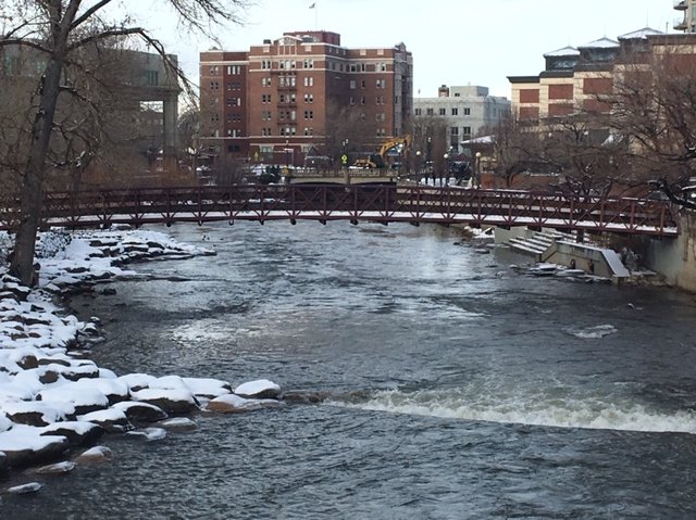
Lake Street Bridge, Arlington Street Bridge and Sierra Street Bridge in downtown Reno will likely be closed for several days. Officials are waiting for river waters to recede so the bridges can be inspected for damages before they can reopen. Please plan to take an alternate route.
The Washoe County Sheriff's Office continues to warn the public to pay attention to road signs that advise of impassable conditions over the Donner Pass area. Multiple vehicles have been stuck on Henness Pass Road above Dog Valley. This is not a safe I-80 alternate route, despite some GPS directions.
Debris removal:
If you see debris in the road, or clogged storm drains, please call 775-337-5800 on Tuesday, January 10 between 8 a.m. - 5 p.m.
Shelters:
Sparks High and Wooster High evacuation shelters are closed as of 5 p.m. Monday as the Washoe County School District prepares to return to class tomorrow.
Evacuations:
All voluntary evacuations announced by Washoe County have been lifted at this time. People can return home.
If you are returning to your home after evacuating, please look for exposed gas pipes in the yard or a rotten-egg smell. If you suspect a gas leak, call 911 and evacuate your home.
City of Sparks update:
For more information from the City of Sparks, please visit cityofsparks.us/floodinfo.
Washoe County School District Update (WCSD):
All WCSD Schools including Incline Village Schools will be on a two-hour delayed start on Tuesday, January 10 to properly prepare schools for welcoming back students and to ensure that all students and staff arrive safely at school. In addition, there will be no Early Release on Wednesday, January 11 at all WCSD schools. All schools will release at the normally scheduled time on Wednesday.
How to get information:
Officials will be updating media and the public continuously at www.washoecounty.us.
For information, please call 775-337-5800 from 8 a.m. - 5 p.m.
People are urged to follow the conversation on social media using the hashtag #NVFlood17.
In an emergency situation, please call 9-1-1.
###
1 p.m.-Regional partners focus on recovery efforts, providing resources to community
Reno, Nevada. Jan. 9, 2017. Washoe County, City of Reno and City of Sparks emergency officials are shifting their focus to recovery efforts following widespread flooding in the region in the aftermath of heavy rains. Ensuring public safety and providing resources to the community remain the highest priorities today.
Weather update:
Northern Nevada should expect to see a fairly active winter storm pattern over the next few days with a declining risk of flooding.
There is a continuing risk of falling trees due to high winds and saturated ground. Trees could fall without warning.
Recovery efforts and damage assessment:
Teams are working around the clock to assess and document damage. This includes reopening roads, when safe, and turning traffic signals back on. The Regional Transportation Commission will be offering free rides through tonight at midnight.
As the process takes place, emergency officials are urging citizens to avoid nonessential travel. Drivers should be extra cautious of standing water and debris if they must travel on area roads.
Road closure information:
Current road closure information is listed on Washoe County’s website.
The Washoe County Sheriff's Office is warning the public to pay attention to road signs that advise of impassable conditions over Donner Pass area. Multiple vehicles have been stuck on Henness Pass Road above Dog Valley. This is not a safe I-80 alternate route, despite some GPS directions. WCSO advises people to stay in Reno until the road has been cleared.
Debris removal:
If you see debris in the road, or clogged storm drains, please report them by calling 211 or 775-337-5800.
Shelters:
As the Washoe County School District prepares to return to normal operations, the Sparks High and Wooster High evacuation shelters will both close at 5 p.m. today.
Plans are being made for the limited number of people who remain at these locations.
If people need a place to stay, they are asked to contact the local Red Cross at (775) 848-2926. The after hours number is (775) 856-1000,
Current evacuation information by street is listed on Washoe County’s website.
City of Sparks update:
For more information on how the City of Sparks is preparing for the storm, go to cityofsparks.us/floodinfo.
Washoe County School District Update (WCSD):
All WCSD Schools including Incline Village Schools will be on a two-hour delayed start on Tuesday, January 10 to properly prepare schools for welcoming back students and to ensure that all students and staff arrive safely at school. In addition, there will be no Early Release on Wednesday, January 11 at all WCSD schools. All schools will release at the normally scheduled time on Wednesday.
Reno-Sparks Indian Colony (RSIC):
The Reno-Sparks Indian Colony (RSIC) is changing its emergency operations to recovery operations today, after RSCI Chairman Arlan D. Melendez signed a Declaration of an Emergency Disaster. RSIC crews focused on flooding at the Reno-Sparks Tribal Health Center and mudslides along Eagle Canyon Road.
If residents see flooding or notice debris on or near their property, they should call RSIC Public Works at 775-785-1341.
Avoid flood waters:
The Reno Fire Department and the Truckee Meadows Fire Protection District have rescinded the exclusion zone that had been set up on both sides of the Truckee River during the flood stage
However, first responders are still urging the public to stay away from the Truckee River. If first responders have to perform river rescues, it will divert valuable resources.
How to get information:
Officials will be updating media and the public continuously at www.washoecounty.us. People are urged to follow the conversation on social media using the hashtag #NVFlood17, or by calling 2-1-1 for information.
In an emergency situation, please call 9-1-1.
###
All updates will be posted on this page. Scroll down to see earlier updates.
5:15 a.m. - Citizens should prepare for challenging morning commute
Reno, Nevada. Jan. 9, 2017 – Washoe County, City of Reno and City of Sparks emergency officials are urging citizens to avoid nonessential travel this morning as widespread flooding continues in Washoe County. Drivers should be extra cautious of standing water and debris if they must travel on area roads.
Road openings:
Crews have been able to reopen the following roads:
- Sierra St. between N. Virginia St. and 15th St.
- Offenhauser Dr. at Portman Ave.
- Aquila Ave. between Plumb Ln. and Thomas Jefferson Dr.
- 9th St. between Lake St. and Evans Ave.
- Gateway Dr. at Offenhauser Dr.
- South Meadows Pkwy between Double Diamond Pkwy and Wilbur May Pkwy
- US 395A between East Lake Blvd. and Mt. Rose Hwy
- SR 431 between Galena DOT Station and Incline Village
Road closures:
Several significant road closures continue to impact the community, which will affect the morning commute. These include large sections of McCarran Boulevard, some downtown bridges, several streets in the Hidden Valley area, and several streets in the Lemmon Valley area. Road access in and out of Pyramid Lake (State Routes 445, 446 and 447) remains closed.
Damage assessment teams will be deployed today to tour the region and determine flood impact and necessary cleanup.
Current road closure information is listed on Washoe County’s website.
Evacuations:
Voluntary evacuations are now in place for 19 dwellings in the Hidden Valley area, due to rising waters. These include dwellings on Pebble Beach Drive, Pelham Drive and Plum Hollow Circle.
Current evacuation information by street is listed on Washoe County’s website.
Truckee River:
According to current information, the Truckee River crested, or reached its highest level, in downtown Reno at around 12:45 a.m. The river is now expected to crest in Sparks some time between 10 a.m. and noon on Monday, which could cause substantial flooding in the Sparks industrial area.
Officials will be updating media and the public continuously at www.washoecounty.us. People are urged to follow the conversation on social media using the hashtag #NVFlood17, or by calling 2-1-1 for information.
In an emergency situation, please call 9-1-1.
12:30 a.m. - Truckee River beginning to level off in downtown Reno; Several significant road closures continue to impact community
Reno, Nevada. Jan. 9, 2017 – Washoe County, City of Reno and City of Sparks emergency officials are monitoring conditions as widespread flooding continues in Washoe County.
According to current information, the Truckee River is beginning to level off in downtown Reno. The river is expected to crest in Sparks some time between 6 a.m. and noon on Monday.
REMSA has reported no flood-related injuries, but has responded to various rescue situations.
Road closures:
Current road closure information is listed on Washoe County’s website.
Three roads traveling to Pyramid Lake have been washed out and the Nevada Department of Transportation is currently working to re-establish access. State Route 445 from Sparks to Sutcliffe and State Route 447 from Wadsworth to Gerlach are currently inaccessible. State Route 446 is inaccessible from mile marker 3 to State Street. Emergency services from Pyramid Lake Paiute Tribe are still available for people in Nixon, Sutcliffe and Wadsworth. For more information, contact 775-574-2426.
Throughout northern Nevada, there have been reports of drivers going around or through posted road closures. Please obey signs, which are there for the safety of drivers, and do not drive in floodwaters. Nonessential travel should be avoided at this time. If you have to drive on roads that are open, be extremely cautious and watch for debris.
Evacuations:
Several dwellings have been evacuated at this time. Residents in the Quilici Drive, Autumn Hills Drive and North Edison Way areas are under voluntary evacuation. Nearly 400 dwellings and nine commercial structures were evacuated in total.
The Autumn Hills Drive area is also affected by a sewer lift station failure that has created a health hazard. Flood waters and tap water should be considered contaminated. Voluntary evacuations are in place in the area bound by Autumn Hills Drive, Amston Road, Huffaker Lane and Offenhauser Drive. The cause of the sewer lift station failure in that area is not yet known, and won’t be until water levels recede and crews can assess the damage.
Current evacuation information by street is listed on Washoe County’s website.
Evacuation center information:
The Wooster High School evacuation center is full. There are approximately 200 people and nine small animals staying there.
People who need a place to stay are encouraged to go to the evacuation center at Sparks High School. There are approximately five people and one small animal staying there.
Office Closures:
These additional places will be closed tomorrow, Monday January 9, 2017:
- Reno Police Department main station front desk, as well as all area substations
- Washoe County has additional closures listed here.
Officials will be updating media and the public continuously at www.washoecounty.us. People are urged to follow the conversation on social media using the hashtag #NVFlood17, or by calling 2-1-1 for information. There have been 1,302 calls made to 2-1-1 yesterday and today.
In an emergency situation, please call 9-1-1.
###
Sunday 6:45 p.m. - Widespread flooding is occurring in Washoe County
Reno, Nevada. Jan. 8, 2017. Washoe County, City of Reno and City of Sparks emergency officials continue to monitor precipitation and flood information as weather conditions continue to deteriorate. Widespread flooding is occurring in Washoe County.
According to current information, the Truckee River is expected to crest, or reach its highest level, around 10 p.m. on Sunday in Reno, and between 1-3 a.m. on Monday in Sparks. See more info from Sparks.
Weather update:
Washoe County has seen significant precipitation, including this rainfall data from the past 24 hours:
- Galena Creek: 4.89 inches
- Rhodes Road: 2.96 inches
- Hidden Valley: 1.26 inches
- Rancho San Rafael: 1.22 inches
- Please see attached rainfall map.
Evacuations:
Several homes have been evacuated at this time. Residents in the Quilici Street, Autumn Hills Drive and North Edison Way areas should evacuate.
The Autumn Hills Drive area is also affected by a sewer lift station failure that has created a health hazard. Voluntary evacuations are in place in the area bound by Autumn Hills Drive, Amston Road, Huffaker Lane and Offenhauser Drive. Please see the attached map for evacuation areas. All streets on the map are in the evacuation zone.
Current evacuation information by street is listed on Washoe County’s website.
Evacuation center information:
The Wooster High School evacuation center is full. People who need a place to stay are encouraged to go to the evacuation center at Sparks High School. Please check road closure information.
Road closure information:
Current road closure information is listed on Washoe County’s website.
Closures:
The following places will be closed tomorrow, Monday January 9, 2017.
- Washoe County District Court (Veterans Court to be held at Jan Evans)
- Washoe County District Attorney
- Washoe County Library-Center Street Location
- Washoe County Technology Services (Edison Way location)
- Washoe County Public Administrator's Office (Edison Way)
- Washoe County Regional Animal Services Office
- Reno City Hall. Reno Direct will not be staffed tomorrow. City of Reno residents should continue to call 2-1-1 for non-emergency information.
- Reno Justice Court
- Reno Municipal Court
- Department of Social Services-350 South Center location
- Sparks Justice Court
- Sparks Municipal Court
- Department of Alternative Sentencing
- Mills B Lane Justice Center
- University of Nevada, Reno
Free Bus Rides:
The Regional Transportation Commission (RTC) is offering free transit rides from now through midnight on January 10, 2017. People should check www.RTCWashoe.com for detours or cancelation of routes.
Avoid flood water:
An exclusion zone with has been set up on both sides of the river by the Reno Fire Department and Truckee Meadows Fire Protection District from the stateline to the City of Sparks, due to life and safety issues. Per the International Fire Code, recreational river-goers or observers within 100 feet of the water could be cited with misdemeanors.
First responders are also urging the public to stay away from the Truckee River. If first responders have to perform river rescues, it will divert valuable resources away from the flood response.
Treat any flood water as contaminated water. The water could include sewage and fertilizer or other contaminants. Stay out of the water and keep pets out of the water, as well.
Flash flooding can happen quickly and can be very dangerous. The water is very cold and hypothermia could set in quickly.
Obey signs, including road closures and do not drive in floodwaters. If you can’t see the ground, you don’t know how deep the water is, if the road is washed out or if you’ll get stuck in debris. Downed power lines could also pose an electrocution risk. Don’t drown, turn around.
Officials will be updating media and the public continuously at www.washoecounty.us. People are urged to follow the conversation on social media using the hashtag #NVFlood17, or by calling 2-1-1 for information. In an emergency situation, please call 9-1-1.
Sunday 11:45 a.m. - Flooding could start at around 2 p.m. today
 Reno, Nevada. Jan. 8, 2017 – Washoe County, City of Reno and City of Sparks officials continue to prepare for a significant flood event that will strongly impact the region today, Sunday, January 8, 2017. The forecast shows flooding starting at around 2 p.m. today in downtown Reno and possibly lasting through around noon tomorrow, according to the National Weather Service in Reno.
The Truckee River Flood Management Authority has released a new set of maps showing the simulated flooding. The maps are available online. Please review the maps and prepare for flooding.
Sandbag information is available at the following links:
- Washoe County
- City of Reno - a seventh sandbag location has been added today in the City of Reno
- City of Sparks
“The flood simulation maps represent a valuable tool,” said Jay Aldean, Executive Director of the Truckee River Flood Management Authority. “This is the first time we’ve been able to translate weather forecast data into almost-real-time information for emergency responders on the ground.”
Flood events are unpredictable, and officials are keeping an eye on downtown Reno, the Steamboat Creek area including low-lying areas of Damonte Ranch, the Hidden Valley subdivision and nearby areas, and the Rosewood Lakes area. The Reno-Tahoe International Airport is now forecast to flood less than projected, but this does not mean that the flood risk has decreased in other areas.
The City of Reno, the City of Sparks and Washoe County have closed all public parks located along the Truckee River.
Temperatures and snow elevations are changing rapidly. Snowmelt is unpredictable and is causing water runoff to go in unexpected directions.
Evacuation centers are open at Sparks High, Wooster High and Natchez Elementary in Wadsworth.
First responders are also urging the public to stay away from the Truckee River. If first responders have to perform river rescues, it will divert valuable resources away from the flood response.
The flood waters are extremely dangerous. Flash floods can happen without warning. The water is fast and cold, which can be a deadly combination. Hypothermia can set in quickly. Please treat any flood water as contaminated water, as it could include sewage, fertilizer and other contaminants. Please keep pets out of the water, too, as they could absorb contaminants and transfer them to humans.
Do not drive in floodwaters. If you cannot see the ground, you don’t know the water’s depth. The road could be washed out, or you could get stuck in debris. Downed power lines could also pose an electrocution risk. Don’t drown, turn around.
Washoe County Sheriff Chuck Allen said he has increased staffing throughout this event. However, response time could be delayed due to weather conditions and increased call volume. There will be several road closures.
“My advice to residents is to stay home if it all possible,” Sheriff Allen said. “Stay put, stay safe, stay away from water. It is also very important to stay up-to-date on the latest weather and road conditions.”
Officials will be updating media and the public throughout the day at washoecounty.us. People are urged to follow the conversation on social media using the hashtag #NVFlood17, or by calling 211 for information. In an emergency situation, please call 911.
###
Sunday 10:45 a.m. - Media Advisory: Northern Nevada regional partners hold Press Briefing at 1:30 p.m. today
What: Officials from the Regional Emergency Operations Center will be holding a press briefing regarding projected floods.
When: 1:30 p.m. today, Jan. 8, 2017
Where: Regional Emergency Operations Center Media Briefing Room, 5195 Spectrum Blvd. Reno, NV
Details: Washoe County, City of Reno and City of Sparks officials continue to prepare for a significant flood event that will strongly impact the region starting today. Heavy rain is expected, leading to an increased threat for flooding near the Truckee River, as well as creeks, streams, drainage ditches, urban areas, farmland and burn areas. The briefing will provide an update with the most recent information as well as flood and storm projections.
Editor’s Note: After the briefing officials will be available for individual interviews. Through an escorted tour, media will have the opportunity to obtain footage and photos in the Regional Emergency Operations Center.
###
Saturday 2:45 p.m. - Arlington & Sierra Bridges open with restrictions.
Reno, Nevada. Jan. 7, 2017. Two bridges in the City of Reno, the Arlington and Sierra bridges, are open with restrictions. Those bridges were scheduled to close today for potential flooding, but they are now open with restrictions. The Lake Street Bridge continues to be closed.
Saturday 1 p.m. - Northern Nevada regional partners continue to prepare for significant flood event.
Reno, Nevada. Jan. 7, 2017. Washoe County, City of Reno and City of Sparks officials continue to prepare for a significant flood event that will strongly impact the region starting tomorrow, Sunday, January 8, 2017. Heavy rain is expected, leading to an increased threat for flooding near the Truckee River, as well as creeks, streams, drainage ditches, urban areas, farmland and burn areas.
Washoe County Emergency Manager Aaron Kenneston reminded officials from the various agencies today that the region is still in Flood Alert Stage. The Regional Emergency Operations Center has been activated for the duration of the event.
According to the National Weather Service in Reno, there is a Flood Warning in effect from approximately 1 p.m. on Sunday to approximately 11 p.m. Monday. Anticipated peak flooding times will be between 5-8 p.m. on Sunday in Reno, and 3-7 a.m. on Monday in Sparks.
Residents are advised to stay home, if possible, and to avoid nonessential travel in order to stay safe and with respect to emergency operations. Residents should be cautious that flood waters could be sewer contaminated. View Washoe County Health District Flood Health & Safety Information.
Washoe County Sheriff Chuck Allen said he has increased staffing throughout this event. However, response time could be delayed due to weather conditions and increased call volume. There will be several road closures.
Download footage of Truckee River shot from Sheriff's Office RAVEN Helicopter
“My advice to residents is to stay home if it all possible,” Sheriff Allen said. “Stay put, stay safe, stay away from water and out of the backcountry. It is also very important to stay up to date on the latest weather and road conditions.”
Key updates are as follows:
Wooster High School and Sparks High School have been activated as the primary regional shelters as of today at noon. People and small animals are welcome at these locations.
For large livestock animals, residents should use the Reno-Sparks Livestock Events Center (1350 N. Wells Avenue in Reno). They can enter at Gate 6 off of Sutro Street.
Sandbag information is available at the following links:
- Washoe County
- City of Reno - a seventh sandbag location has been added today in the City of Reno
- City of Sparks
Citizens are urged to please use sandbags prudently, with respect to the high demand.
Please be advised that all Washoe County School District schools are canceled for Monday, January 9, 2017 due to predicted severe and dangerous weather conditions. The school district will review weather implications for Incline Village schools on Sunday, January 8, 2017 and will contact Incline families if schools are safely able to open there. Visit washoeschools.net for further updates.
In anticipation of significant flooding, several downtown Reno buildings will be closed on Monday morning, including the three courts: Reno Municipal Court, Second Judicial District Court and Reno Justice Court.
Alternatively, the Jan Evans Juvenile Justice Center will remain open. Veterans Court will be held at Jan Evans Juvenile Justice Center at 650 Ferrari-McLeod Blvd., Reno 89512. Veterans Court participants should arrive at 9:30 a.m. Temporary Protection Order (TPO) applicants may go to the Jan Evans Juvenile Justice Center at Ferrari-McLeod Blvd between 9 a.m. and 3 p.m. to complete a TPO application or call 775-328-3468 for assistance. January 9 will be a non-judicial day for purposes of calculating filing deadlines.
The Downtown Reno Library will be closed, along with several businesses. Because the flooding is likely to occur through Monday, it is important to understand that flood-prone facilities will likely be inaccessible on Monday morning.
The following City of Reno bridge closures will happen at 2 p.m. today: Lake, Arlington and Sierra.
The Sparks industrial area will be severely impacted. For more information on how the City of Sparks is preparing for the storm, go to cityofsparks.us.
No Regional Transportation Commission routes are inoperable at this time, but RTC is assessing based on changing conditions. Riders should plan for possible delays due to road conditions.
The Reno-Tahoe Airport Authority leadership team will be manning the airport emergency operation center starting tomorrow afternoon. Airport officials have been working in close concert with the National Weather Service and the Washoe County emergency management team for the past 10 days planning for the storm. The airport has communicated to all the airlines and tenants that there is a flood risk. The airport has filled 2,000 sandbags and have more if needed.
How to get information:
Call 2-1-1 if you have non-emergency questions, follow the hashtag #NVFlood17 on social media, or use the specific communications channels for each entity described below. For more information, visit washoecounty.us.
*Call 9-1-1 in an emergency situation.
Official hashtag:
Media and the public are encouraged to ask questions and share information on social media by using the hashtag #NVFlood17.
###
Friday, 4 p.m. - State of Emergency Declared
 Reno, Nevada. Jan. 6, 2017. Washoe County, the City of Reno and the City of Sparks have all declared a State of Emergency in preparation for the significant flooding event forecast for this weekend. These declarations have been submitted to the State of Nevada and will allow regional partners to speed up the delivery of resources required to more effectively respond to an emergency and meet the needs of the community during a time of crisis.
In addition, Washoe County Emergency Manager Aaron Kenneston has elevated the alert stage from Monitoring Stage to Flood Alert Stage, which occurs 48 hours before flooding is expected. See flood projection maps.
The Regional Emergency Operations Center has been activated for the duration of the event.
According to the National Weather Service in Reno, there is a Flood Warning in effect from Sunday to Monday. Residents should also be prepared for a Winter Weather Advisory on Saturday, Jan. 7, 2017, from 4 a.m. to 4 p.m. Saturday’s storm could bring more snow to the region.
Sparks High School is being established as the primary shelter and will be open Saturday, Jan. 7, 2017 at noon. Wooster High School is on standby, should a secondary shelter be needed.
How to get information:
Call 2-1-1 if you have non-emergency questions, follow the hashtag #NVFlood17 on social media, or use the specific communications channels for each entity described below. For more information, visit www.washoecounty.us.
*Call 9-1-1 in an emergency situation.
Official hashtag:
Media and the public are encouraged to ask questions and share information on social media by using the hashtag #NVFlood17. For the latest information on Twitter, follow us at www.twitter.com/washoecounty.
Washoe County update:
Declaring an emergency allows the County Manager to speed up the delivery of resources required to more effectively respond to an emergency and meet the needs of the community during a time of crisis.
“The State of Emergency Declaration for Washoe County will be delivered to the Governor later today,” Washoe County Manager John Slaughter said. “The declaration has been made so that Washoe County can make requests of the State for resources as soon as possible in order to be available on-site and ready to go by this weekend.”
Washoe County Chairman Bob Lucey said Washoe County is working hard to prepare for the pending storms.
“We will do whatever we need to do to make sure all the citizens of Washoe County are safe. We want the community to know we are working with our regional partners to mitigate any damage that could be caused by this storm,” Chairman Lucey said.
The Washoe County Roads Division is busy making sure roads are as safe as possible. There are nine sandbag locations available throughout unincorporated Washoe County. See the complete list.
Avalanche danger continues to exist in the Sierra. The Washoe County Sheriff’s Office urges citizens to stay out of the backcountry until the danger passes. Avalanche experts have also expressed concern about a high probability of an avalanche in the Third Creek drainage area above Incline Village. At this time, we do not believe homes in the area are threatened.
Washoe County Regional Animal Services will have the Reno Livestock Events Center available as a shelter for residents with animals in flood prone areas beginning Saturday, Jan. 7, at noon.
Washoe County School District update:
Washoe County School District will continue to evaluate the situation and a decision on possible school closures or delays will be announced as soon as possible.
City of Reno update:
The City of Reno is prepared to mitigate potential damage that could be caused by flooding.
“I want the citizens of Reno to know that we have learned from past flooding events in this region and that we are more prepared than ever before,” said Reno Mayor Hillary Schieve. “I urge everyone to prepare for flooding, including sandbagging flood-prone areas and making sure you and your family have an emergency plan and extra supplies. Safety is of the utmost importance.”
Public Works will be working around the clock until there is no longer a concern for public safety. Crews will be clearing storm drains to avoid water over roadways and preparing for potential flooding along the Truckee River by filling sandbags, removing debris, and inspecting bridges in high-flow areas. This includes the following bridge closures starting tomorrow at noon: Arlington, Lake and Sierra bridges.
The Reno Fire Department and the Reno Police Department are both adding additional staffing over the weekend to prepare for potential emergency situations.
Sandbags are available at six locations. Locations can be found at Reno.Gov/News. Businesses and residents along the Truckee River corridor should be on high alert and take precautions to protect their property.
The public and City of Reno employees should anticipate the closure of Reno City Hall on Monday morning, and plan accordingly.
City of Sparks update:
For more information on how the City of Sparks is preparing for the storm, go to www.cityofsparks.us.
Regional Transportation Commission:
Due to predicted flooding, RTC bus routes may be inoperable in flood-prone areas as conditions warrant. All riders are advised to plan ahead and monitor www.rtcwashoe.com for updated information. Click on Transit Alerts. Additionally, RTC buses are on standby to assist with evacuations this weekend and early next week if called on by first-responders or law enforcement. However, residents should plan on being self-sufficient during the flood emergency and prepare in advance. Precautions for flooding are also taking place at RTC construction sites, such as moving equipment to higher ground. The RTC encourages everyone to monitor media reports and to be safe and prepared.
Volunteer
For those interested in volunteering, contact Northern Nevada Red Cross at 775-770-0899.
# # #